


Precinct 17, Lewis and Clark County, Montana
About
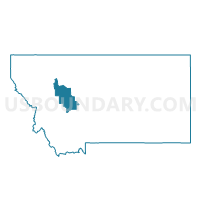
Outline

Summary
| Unique Area Identifier | 612072 |
| Name | Precinct 17 |
| County | Lewis and Clark County |
| State | Montana |
| Area (square miles) | 3.84 |
| Land Area (square miles) | 3.81 |
| Water Area (square miles) | 0.03 |
| % of Land Area | 99.22 |
| % of Water Area | 0.78 |
| Latitude of the Internal Point | 46.60880690 |
| Longtitude of the Internal Point | -111.99340650 |
Maps


Graphs
Select a template below for downloading or customizing gragh for Precinct 17, Lewis and Clark County, Montana


Neighbors
Neighoring Voting District (by Name) Neighboring Voting District on the Map
- Precinct 13, Lewis and Clark County, MT
- Precinct 15, Lewis and Clark County, MT
- Precinct 16, Lewis and Clark County, MT
- Precinct 18, Lewis and Clark County, MT
- Precinct 24, Lewis and Clark County, MT
- Precinct 33, Lewis and Clark County, MT
- Precinct 34, Lewis and Clark County, MT
- Precinct 54, Lewis and Clark County, MT
Top 10 Neighboring County Subdivision (by Population) Neighboring County Subdivision on the Map
Top 10 Neighboring Place (by Population) Neighboring Place on the Map
- Helena city, MT (28,190)
- Helena Valley Southeast CDP, MT (8,227)
- Helena Valley West Central CDP, MT (7,883)
- Helena Valley Northeast CDP, MT (2,995)
Top 10 Neighboring Elementary School District (by Population) Neighboring Elementary School District on the Map
Top 10 Neighboring Secondary School District (by Population) Neighboring Secondary School District on the Map
Top 10 Neighboring State Legislative District Lower Chamber (by Population) Neighboring State Legislative District Lower Chamber on the Map
- State House District 80, MT (10,727)
- State House District 78, MT (10,708)
- State House District 79, MT (8,612)
Top 10 Neighboring State Legislative District Upper Chamber (by Population) Neighboring State Legislative District Upper Chamber on the Map
Top 10 Neighboring 111th Congressional District (by Population) Neighboring 111th Congressional District on the Map
Top 10 Neighboring Census Tract (by Population) Neighboring Census Tract on the Map
- Census Tract 12.01, Lewis and Clark County, MT (6,709)
- Census Tract 4, Lewis and Clark County, MT (5,958)
- Census Tract 5.02, Lewis and Clark County, MT (5,898)
- Census Tract 11, Lewis and Clark County, MT (5,548)
- Census Tract 9, Lewis and Clark County, MT (3,895)